The issue of the shrinking commons in expanding cities is often dismissed as an unavoidable cost of modernization, but a closer look at the spatial data reveals a deeply fragmented urban crisis
Shashwat Bhatnagar | June 12, 2026
")
For centuries, the urban framework of Varanasi was defined not just by its relationship with the sacred Ganga but by its multifaceted network of urban commons. Historic kunds, seasonal talabs (ponds), and open maidans served as the city’s basic ecological infrastructure. They acted as natural flood mitigators during the intense monsoon spells and critical groundwater rechargers during the blistering Indian summers.
However, as India’s tier-II cities experience an unprecedented real-estate and infrastructure boom, the nature of these spaces is changing fundamentally. Walk through the peripheral expansion of Varanasi today along the newly made ring roads, and the expanding airport corridor, and the ancient topography is unrecognizable. The open fields where communities gathered are rapidly being paved over by concrete grids. The issue of the shrinking commons in expanding cities is often dismissed as an unavoidable cost of modernization, but a closer look at the spatial data reveals a deeply fragmented urban crisis.
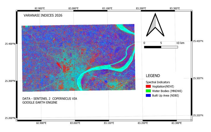
The 2026 spatial layout reveals a deeply fragmented urban landscape, exposing a stark contrast between Varanasi's historic urban core and its rapidly evolving peri-urban fringes. By analyzing the intersection of spectral indicators,which map vegetation via the Normalized Difference Vegetation Index (NDVI), surface water via the Modified Normalized Difference Water Index (MNDWI), and concrete infrastructure via the Normalized Difference Built-Up Index (NDBI), The map highlights how aggressively the physical footprint of the city is changing along its fringes.
India’s skill development programmes were designed with a goal to make the young population ready with market-required skills and competencies, and to provide them with better employment opportunities. Yet the outcomes have fallen short of that goal: though over 1.6 crore individuals were trained acr
The Union Cabinet on Wednesday passed a resolution marking June 10, 2026, as a historic milestone in the journey of Indian democracy applauding Narendra Modi for becoming the longest-serving elected PM of the country. By establishing a record of 4,399 days of continuous service as an elected PM, he has s
A teacher was appointed in 1999, before the Right to Education (RTE) Act came into force, and appointed under the rules that existed at that time. She gave the necessary test, passed it, passed the interview, and was appointed. Over the next 26 years, she taught thousands of children, faced transfer orde
In a step towards the operationalisation of the Bharat Audyogik Vikas Yojana (BHAVYA), union minister of commerce & industry Piyush Goyal launched the BHAVYA Portal on Monday in New Delhi. Addressing the gathering, Goyal said that the BHAVYA scheme will adopt a competit
The finance ministry on Friday announced a series of measures aimed at enhancing the ease of investment for individual Persons Resident Outside India (PROIs) and Foreign Portfolio Investors (FPIs), and to attract stable long-term foreign capital flows. Building on the recent in
Majuli Island, perched between the Brahmaputra River to the south and east, the Subansiri River to the west, and a branch of the Brahmaputra to the north, has been severely affected by recurrent flooding and intense riverbank erosion. Despite its global importance in acquiring UNESCO tentative status for