In Varanasi, fringe expansion vs. core heritage

The issue of the shrinking commons in expanding cities is often dismissed as an unavoidable cost of modernization, but a closer look at the spatial data reveals a deeply fragmented urban crisis

Shashwat Bhatnagar | June 12, 2026


#Environment   #Urban Governance   #Varanasi  
A Ganga Ghat in Varanasi (Photo: Governance Now)

For centuries, the urban framework of Varanasi was defined not just by its relationship with the sacred Ganga but by its multifaceted network of urban commons. Historic kunds, seasonal talabs (ponds), and open maidans served as the city’s basic ecological infrastructure. They acted as natural flood mitigators during the intense monsoon spells and critical groundwater rechargers during the blistering Indian summers.

However, as India’s tier-II cities experience an unprecedented real-estate and infrastructure boom, the nature of these spaces is changing fundamentally. Walk through the peripheral expansion of Varanasi today along the newly made ring roads, and the expanding airport corridor, and the ancient topography is unrecognizable. The open fields where communities gathered are rapidly being paved over by concrete grids. The issue of the shrinking commons in expanding cities is often dismissed as an unavoidable cost of modernization, but a closer look at the spatial data reveals a deeply fragmented urban crisis.

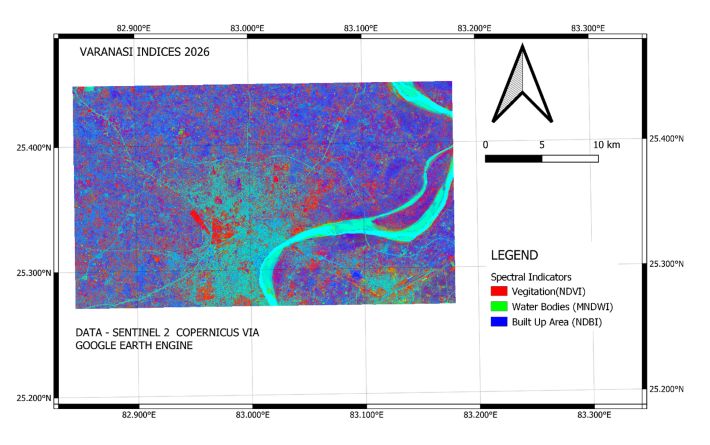
The 2026 spatial layout reveals a deeply fragmented urban landscape, exposing a stark contrast between Varanasi's historic urban core and its rapidly evolving peri-urban fringes. By analyzing the intersection of spectral indicators,which map vegetation via the Normalized Difference Vegetation Index (NDVI), surface water via the Modified Normalized Difference Water Index (MNDWI), and concrete infrastructure via the Normalized Difference Built-Up Index (NDBI), The map highlights how aggressively the physical footprint of the city is changing along its fringes.


Figure 1 - Spectral Indicators of Varanasi
 
The spatial distribution of these indicators tracks two different urban realities on the ground. 
 
The Consolidated Core is a prominent purple matrix of built-up areas that traces the historic core along the prominent crescent bend of the Ganga with a high degree of compactness and density. There is high water reflectance, and isolated regions of density are present in this dense fabric. These reflect the city's iconic heritage kunds and community tanks, systematically revived, dredged, and concrete-lined as a part of the recent Smart City initiatives, which now have a clear and reflective water even in the scorching heat of May. 
 
The Fragmented Peri-Urban Fringe: As the urban fabric progresses further towards the north and the west, it becomes chaotic along the transit corridors to Harhua and the axis to Babatpur airport. It is quite a different scene here, with numerous small, disjointed water pixels making a big impact. The ground-level realities make it clear that these are not ecological commons nor healthy wetlands but instead are the imprint of aggressive resource extraction. They are deep excavations of brick kilns and infrastructure clearings that pierce through the urban edge, for a while bringing stagnant run-off to the surface, while the surrounding agricultural lands are systematically paved over.
 
The spatial configuration of the built fabric in Varanasi has been observed through the lens of the concrete matrix, as it gets expanded outwards in the spatial arrangement of 2026. This has been systematically replacing the open, permeable surfaces of the city with impermeable concrete grids, measured by the high density of the Normalized Difference Built-Up Index (NDBI). This large-scale conversion of peripheral catchments comes at a time of significant dual crisis in a dense historic urban environment – localized flooding of streets and urban heat intensification. Seasonal lows and isolated talabs, as well as low-lying agricultural fields, are covered with asphalt and concrete, and the natural drainage pattern of the landscape is immediately disrupted. The shallow water table in this locality is lowered, and rainfall no longer infiltrates into the soil to recharge the area. Rather, as soon as the pre-monsoon rains or early monsoon hit the area, local roads turn into artificial drains, and run-off rushes straight through the newly created pockets of residences, which are devoid of any formal stormwater drainage system.
 
Simultaneously, this spatial transformation changes the microclimate of the area. The vegetative commons (the little red dots on the map) are replaced by massed buildings, which retain heat and acquire the properties of a building structure. These surfaces, both concrete and brick, are very hot in the day and cool slowly at night, reflecting the strong solar radiation they absorb. This trade will create a series of recognizable micro Urban Heat Islands (UHIs) in the “new commercial zones” located in the outer corridors of the city: this will be a local environmental change that will cause a seasonal heat stress on the periphery of the city, which will be increasingly pronounced and problematic over the course of a season.
 
Mapping the fragmentation in the urban landscape of the peri-urban fringe in Varanasi raises a significant institutional challenge in current urban management. The physical change of open ground to concrete is very fast, while the statutory planning systems, whose job it is to control this change, are extremely conservative and reactive. 
 
The Master Plans created for Tier-2 cities are often inaccurate once formally notified, and are unable to keep up with or safeguard the edge-land commons from aggressive real estate and infrastructure development pressures. 
 
One of the major structural reasons for this peripheral crisis is the issue of serious technical and fiscal capacity deficit in Urban Local Bodies (ULBs). The 74th Constitutional Amendment Act entails a decentralized mandate for municipalities with the idea of them functioning as self-governing institutions for environmental and spatial planning. In practice, however, local authorities often do not have a dedicated and functional GIS or spatial monitoring cell. Municipal administrations are in the dark on the urban fringe, unless evaluated routinely by satellites and/or automated geo-fencing tools. 
 
Encroachments on Gram Sabha (village council) common lands, natural drainage, and minor local water bodies usually do not get identified at the outset. In contrast, the illegal activities are generally only identified after permanent concrete construction has been completed, and the local government is forced to attempt to clean up the mess of illegal growth in a piecemeal fashion by trying to fix the problems that already occurred. As a result, the urban commons are "managed" as empty space that has lower value and can be constructed upon, instead of a very important element of nature, which is crucial for the city's long-term climate resilience.
 
Shashwat Bhatnagar is a Master's student pursuing a Master's in Cities and Governance from the School of Public Policy and Governance, Tata Institute of Social Sciences, Hyderabad.

Comments


Other News

How to listen to the great storytellers that the trees are

The Trees of My Country: A Natural History of India in 50 Trees By T. R. Shankar Raman, with illustrations by Manali Patil Aleph Book Company, 284 pages, Rs 1,499  

This tree in Bihar turns out to be the oldest accurately dated banyan

A banyan tree in Munger, Bihar, estimated to be around 700 years old, has been identified as the oldest accurately dated banyan tree, Ficus benghalensis, using radiocarbon dating, a method that relies exclusively on scientific evidence rather than historical records or local lore. Banyan

Corporate Governance 3.0: What the boardroom of 2030 will look like

The phrase "corporate governance" often evokes images of board meetings, compliance checklists, and regulatory filings. For years, governance was viewed primarily as a mechanism to prevent fraud, protect minority shareholders, and ensure regulatory compliance. However, the events of the last deca

India, Japan open "a new chapter in special strategic and global partnership"

India and Japan are opening a new chapter in their special strategic and global partnership with the visit of prime minister Sanae Takaichi, India`s prime minister Narendra Modi said on Thursday,   "I had said in the G7 summit a few days ago that, in this environment of

AI studies sun images to track bright solar regions

Artificial Intelligence has been used to trace the shift in magnetically active patches on the Sun from 1916 to 2007 by scanning 100 years of hand-drawn Sun records from the Kodaikanal Solar Observatory (KoSO). This could give a much longer view of how solar activity changes over time.  

General Dhiraj Seth takes over as Chief of Army Staff

General Dhiraj Seth, PVSM, UYSM, AVSM, took over as the 31st Chief of the Army Staff (COAS) from General Upendra Dwivedi, PVSM, AVSM, who superannuated after more than four decades of distinguished service to the nation on Tuesday.   General Dhiraj Seth is an alumnus of the N


Archives

Current Issue

Opinion

Facebook Twitter Google Plus Linkedin Subscribe Newsletter

Twitter