From assessing risks to saving lives and making damage assessment, GIS is revolutionising the way we deal with natual calamities
Disasters are spatial in nature. They strike at a specific location and influence a particular area. Thus, location intelligence plays a critical role in disaster management.
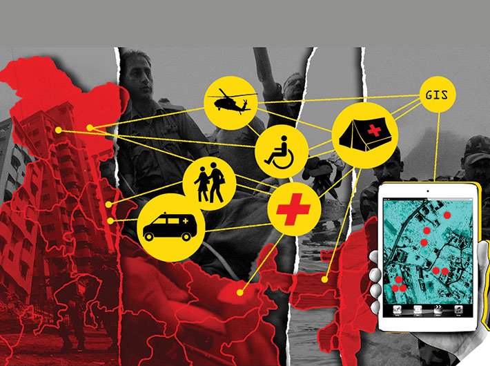
GIS coupled with remote sensing provides a basic framework that helps in all the stages of disaster management starting from preparedness to response and recovery. Through advanced wireless technologies and web-based GIS applications, disaster management by governments and other agencies is being revolutionised and is enhancing the coordination of response efforts as well as planning for disaster risk reduction. GIS decision support systems for disaster have been applied in several parts of the world for effective management.
For assessing disaster risks, one needs an understanding of key disaster event characteristics such as location of impact (for example, earthquake epicentre, cyclone landfall), physical characteristics (magnitude in case of earthquakes, central pressure in case of cyclones), local conditions like land use and type and height of structures. These characteristics require an understanding of the geography of the impacted area in order to model the hazard intensity and severity and to understand the impact on buildings, infrastructure and population and at the same time respond to the disaster for evacuation and rehabilitation works. Use of GIS and remote sensing, helps conduct all these tasks in a planned an efficient manner.
Earlier, when the concept of GIS did not exist, response decisions during disasters were taken mostly on the basis of prior experience and intuition rather than any live information. But today, the existence of GIS empowers us to integrate data from various sources into a common platform and make it readily accessible to various stakeholders. It enables dissemination of critical information, in a timely manner, to focused communities located in the disaster zone. Further, the visualisation of this data helps in analysing a situation and taking quick decisions.
In advanced countries, GIS is being successfully used to address all the components of disaster management – preparedness, mitigation, response and recovery, which are centred on disaster risk assessment and are interconnected.
Awareness and preparedness
Some critical questions that arise during awareness and preparedness for disaster management are: What is the population of the area, location of buildings and infrastructure, social and structural characteristics of the area, population at risk, evacuation time and technique, location of the safe structures that could be used as shelters and others? GIS and remote sensing techniques can be used to build database of critical facilities such as hospitals, ambulances, fire stations, police stations, schools and other places which can be helpful for planning purposes. Mapping unplanned communities is also crucial for disaster preparedness and making these communities more resilient. Using GIS-based disaster risk assessment solutions; hazard and risk maps can be prepared to show the risk zones as well as disaster impact zones. These maps which identify the population, transport and other essential facilities impacted under a disaster scenario help in planning for disaster response. These can be combined to identify the evacuation routes and safe shelter locations along with the transportation mechanism to move the population to safer places. Shelter locations can be defined in GIS along with attribute information such as the number of people it could accommodate, daily food, water and medicine requirements. Once it is known which population is exposed to what type of disasters, awareness campaigns can be planned.
Planning and mitigation
Earlier the role of governments during natural calamities was limited to rescue, relief and rehabilitation. With changing times, mitigation and mainstreaming of disaster risk reduction has become crucial activities requiring government intervention. Mitigation strategies help to reduce the vulnerability of structures and population by either reducing the intensity of the hazard or by improving the resilience to the hazard.
Hazard and risk maps made for hazards like floods, earthquakes and cyclones help in understanding the risk to a structure or community based on the current structural and social capacity. Various structure performance improvement techniques (retrofitting of structures) could be tested to check how they improve the capacity of a structure to sustain a hazard intensity using a GIS-based disaster risk assessment solution. After the Gujarat earthquake of 2001, the government conducted a similar exercise and several critical buildings in the area were retrofitted.
In recent years, in Phailin and Hudhud cyclones, millions of lives were saved because of an early warning system that forewarned the population. The government thus evacuated the vulnerable people before the event could strike.
All the new development projects should consider the risk maps for the area where development is being planned and lay the guidelines for development accordingly. For example, in an earthquake-prone area, guidelines for buildings should include components for earthquake proofing. If the 25-year return period flood height is 1.5 metres then guidelines should set a higher ground elevation, levees could be planned as part of the development activity close to a river, etc.
Response and recovery
Responding to a disaster adequately requires some critical information like the location where the disaster has occurred, intensity and severity of the event in various disaster zones, areas of maximum damage, location of impacted population and the kind of resources needed to evacuate the trapped population. GIS and remote sensing techniques coupled with technologies like satellite imagery, aerial photography using aircraft or drones can help find answers of many such questions. Soon after the occurrence of disaster, use of remote sensing on aerial photographs or satellite images can help map the affected locations and compare the data to historical information to assess the overall damage. While remote sensing aids in identifying the damage, GIS helps to project that damage on the map and correlate it with shelter, hospitals, emergency operation centres, road and transport maps to plan the rescue and relief operations. Using these technologies maps can be created and provided to first responders on handheld devices to guide them to the impacted areas.
Once rescue and relief get completed, the same technologies are used for detailed damage assessment. In case of disasters like earthquakes, damage assessment of buildings and infrastructure is one of the most important aspects of a recovery plan. High resolution satellite imagery coupled with advanced GIS and domain expertise can be used for accurate interpretation and damage analysis. However, there should be a good coordination between GIS organisations and the government. GIS organisations such as RMSI are equipped to turn around such tasks at a faster rate, provided high resolution satellite imageries are made available by the government bodies or private companies. Further, this is supported by on ground sample damage assessment surveys conducted by experts. RMSI experts had participated in such a survey after the Gujarat earthquake, Mumbai floods in 2005, Surat floods in 2006 and Krishna river floods in 2008.
Damage assessment
Damage assessment helps in estimating the number of households damaged and families displaced along with casualities and injured in short term, damaged infrastructure. It also helps in re-establishing communication so that it performs better in future or laying foundation for an emergency communication network that could initiate immediately in the aftermath of a disaster. At the same time, estimates of economic impacts and social impacts can be traced as the information would help in identifying the most affected families, particularly widows, single parent children, orphans, differently-abled persons and senior citizens.
Furthermore, GIS platforms have proved very useful in connecting dislocated families. Open applications with abilities to upload the photographs of missing family members and tagging the location of other family members have been applied for several disasters worldwide. Google has been very proactive in launching such websites after disaster events.
Johari is vice president, risk & insurance, RMSI.
(The article appears in the July 16-31, 2015 issue)