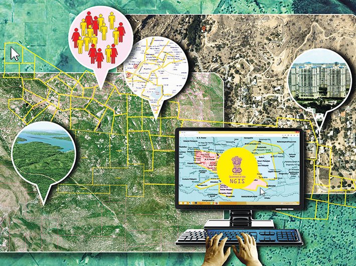
NGIS is set to bring in better planning processes, delivery system, and increased transparency and efficiency in decision-making
With the emphasis on maximum governance, a lot of e-governance initiatives have been launched in the country. E-governance is seen as an effective tool to pave the way for good governance. But is e-governance enough in this era? There exists an opportunity for the country to further build upon its existing mapping/imaging and IT strengths and position a national GIS (NGIS) that will enable g-governance and bring wide-ranging benefits. There is a strong motivation within the country for the realisation of NGIS as the next technology paradigm for effective governance; thereby enabling better planning processes, delivery systems, and increasing transparency and efficiency in the national-level decision-making and reaching developmental benefits to citizens in a unique manner.
NGIS would help India in migrating from e-governance to g-governance in the long term. It would also catalyse and transform the methods in which GIS is practised in the country, the way maps/images as GIS-ready data gets organised and the way customised GIS applications products get created, value added, managed and deployed as unique NGIS services. These unique and innovative NGIS applications would serve the needs of natural resources management, planning and decision support systems and help position transparent and participatory governance by focusing on GIS-based citizen services.
In April 2011, the planning commission floated the idea of constituting NGIS. It established an Interim Core Group (ICG) to prepare a blueprint for the same. ICG submitted its report to the government in October 2011. Since then, it is under the government’s consideration. NGIS is a collaborative effort in which all departments would come together and share data, resources and above all applications. The implementation is shared by the department of science and technology (DST), department of space (DOS), department of electronics and information technology (DeitY) and ministry of earth sciences (MoES). However, initially NGIS will be anchored by DST. The NGIS has also been incorporated into the 12th five-year plan (2012–17) as a new initiative for the future.
NGIS paves the way
The proposed NGIS envisages organisation of NGIS asset and applications products conforming to the standards of ISO/OGC/NSDI/BIS for meeting the user needs. This would leverage input from maps, images and tabular datasets that are generated by public-funded agencies. It will also include harvested data from initiatives like ‘data.gov.in’ and even warrant value-addition and generation of new/additional GIS-ready data that is required by the nation.
The definition of NGIS application products and services is being made through detailed consultations and need assessment with each ministry (and even states) by taking into account the requirements of geospatial data and application needs of the ministries, state governments, civil society and citizens.
Geographic information system (GIS) has been a vendor-driven technology and thus capacity building in government departments is marginal. NGIS envisages making data and technology transparent to the user. This obviates the need for searching and getting the data and understanding the nuances of the technology. The National Data Registry will lead to the data and the National GIS Data Platform (NDP) would serve the applications designed and developed, taking into consideration the various user needs by NGIS Product Development Mission.
At present, the NGIS mission in the country is on a fast-track mode and is being considered at the highest levels in the government. The topographical data is now available in a seamless form generated by the survey of India (SoI) and national spatial data infrastructure (NSDI). However, the data is derived from maps on a scale of 1:50,000. Since a seamless digital frame is available, scale is not significant. Additionally, SoI has a map cover of over 70 percent of the country on 1:25,000 scale and this could be used for densification of details.
Earlier, while discussing the vision for NGIS, it was estimated to cost around '3,000 crore and the major portion of the funds would be needed to generate NGIS Data Assets. A task force on 1:10,000 mapping estimated the cost would be around '1,800 crore for mapping alone. However, due to technological changes and considering the work already done by various agencies in the intervening period, the cost is expected to come down.
Pain points
However, the road towards the NGIS is not an easy one. Data sharing is a major problem. Unless it is made mandatory, individuals and organisations are highly possessive of their data. Formulation and enunciation of National Data Sharing and Accessibility Policy (NDSAP) was spearheaded by the DST. This makes it necessary for data owners to disclose a negative list of data owned by them and then disclose metadata and/or data for open access. Under this, policy data owners are expected to populate data.gov.in portal with sharable data and pricing information, if any. Many states are in the process of evolving such data policy. The national data portal, www.data.gov.in, has large amounts of data, including the SoI map data. All this happened in just over a year after the portal was unveiled. The portal was designed, developed and maintained by the National Informatics Centre (NIC) in consultation with DST.
The next challenge is capacity building. If national GIS has to be successful, we need to have geospatial literacy so that we can maintain geospatial data through informed and controlled crowdsourcing. Many of the products would require dynamic information such as weather and traffic, besides static changes due to fast development of both rural and urban areas.
Also, a policy covering all aspects of geospatial data is the need of the hour. Though we have a National Map Policy, Remote Sensing Data Policy and Aerial Photography Policy, we do not have any policy covering geospatial products and services. DST has been working on a National Geospatial Policy and the draft is almost ready.
The road ahead
There is a need for a national action plan for geospatial literacy and national GIS to empower people. There is no dearth of leadership in this country both inside and outside the government. The country has demonstrated its technical strengths in providing high resolution stereo satellite images (NRSC/DOS), serving seamless Web Map/Feature Services by ensuring interoperability of both topographical data of SoI (NSDI/DST) and satellite images of Bhuvan and also a National Data Portal (NIC/DeitY) developed using open source. The biggest challenge now is to choose the leader.
The government at the highest level can identify the leader easily through expert consultations and search committees. Programmes for capacity building need to be rolled out. The HRD ministry has a report of the task force on geospatial education strategy and it can be considered for implementation.
Also, the private sector can be roped in for providing geospatial literacy. We have a strong private sector in GIS which is providing products and services to many countries and regions, including the US, Europe, Middle East, Australia and Africa.
NGIS should usher in an era of geospatial decision support both for individuals and governments and help them in taking informed decisions, thus truly empowering them. NGIS should match the efficiency, product quality and efforts of foreign service providers and outperform through the value provided.
Following the state model
State governments can also become active partners by integrating state GIS with the national GIS. Delhi has an excellent framework for state GIS, including high resolution data derived from aerial photography in 3D. It is being used by the departments of the government of the National Capital Territory of Delhi. Karnataka and Gujarat have made their state GIS operational without central assistance. These would serve as a stimulus for other states to accelerate their state GIS programmes. However, they need to be linked to NGIS with regard to processes and standards to ensure interoperability. Six states – Gujarat, Karnataka, Andhra Pradesh, Odisha, Rajasthan and Delhi – will be part of the NGIS project.
Dr Kumar, former CEO, NSDI, is the president of geospatial solutions at IIC Technologies, Hyderabad.
(The article appears in the July 16-31, 2015 issue)