Sujala was conceived as a sustainable poverty alleviation-cum-watershed programme. Community participation, satellite-based planning, monitoring and evaluation made it real
Sujala, a comprehensive watershed development project of the Karnataka government, is one of the finest examples of use of satellite imagery in poverty and natural resources management. Implemented with financial assistance from the World Bank, the project was adopted by the central government and launched as integrated watershed development programme.
Close to 79 percent of the state is drought prone. Years of unscientific land and water management practices has led to deterioration in soil fertility, soil loss and decline in crop yield. As a result farmers grew just one crop in a year. The crop yield was two to five times less than optimal. To restore natural resources and ensure livelihood to farmers, the government has been undertaking initiatives since 1984. These efforts, however, lacked an integrated and participatory approach. The initiatives also lacked stringent monitoring and evaluation system.
In 2001, the state government and the World Bank together mooted Sujala, aka, Karnataka watershed development project (KWDP). The objective was to improve productive potential of watersheds, ensure production and livelihood and strengthen local community for natural resource management. The project envisaged providing support to women, landless and vulnerable groups with income generating activities and strengthening capacity of communities for participatory involvement.
The project was implemented in phases. Eventually 738 micro watersheds across 38 taluks and seven districts were planned. The World Bank provided over '678 crore for the project, and insisted on use of advanced technology such as remote sensing and GIS for greater accountability and stringent monitoring and evaluation. That’s how ISRO was brought on board.
Rollout
The strategy adopted by the government and the World Bank was to execute the project with greater community participation. So a public-private-people partnership was devised. While the watershed department was responsible for overall management, non-governmental organisations (NGOs) were given the task of social mobilisation, capacity building and facilitating the preparation of the action plan. ISRO’s job was to provide satellite imagery and monitor and evaluate the project. The Karnataka state remote sensing centre’s job was to use satellite imagery and non-spatial data to make thematic maps for each micro watershed and respective scientific action plans.
These maps laid out the land use and land cover under agriculture (single or double cropping), forests (evergreen, degraded) wasteland (salt affected, water logged, barren, rocky) and human settlements. Some maps provided soil properties and prospects for ground water. The spatial data was integrated with information related to rainfall, demography, literacy, class and caste information. This gave a clear picture of high and low priority areas for the watershed project. A high priority area would typically have higher proportion of wasteland, uncertainty of rainfall, drinking water shortages during summers and presence of vulnerable communities, including scheduled castes and scheduled tribes, and small and marginal farmers. The action plans were made accordingly.
In the first phase, 10 sub watersheds were chosen for implementation, covering an area of 70,000 hectares and 42,000 families. In the second phase, 20 sub watersheds across 1,11,005 hectares and 1,10,000 families were covered. The last phase had 47 sub watersheds, covering an area of 3,25,552 hectares and 1,98,000 families. In total, the project encompasses 1,270 villages and around four lakh families. The project duration was initially five years, starting from 2002. Later it was extended by two years, completing in 2009. The first phase included a village in Chitradurga district, Sankaiyyahati, which in many respects show the important role of GIS and remote sensing technologies in executing projects in remote and far-flung areas.
Impact
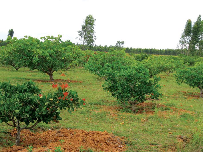
The entire population of the village is predominantly tribal and illiterate. The village land was degraded, had low productivity. The source of water was a pond, which was used for drinking, washing and bathing. Initially, villagers only grew Ragi, Millet and Jowar, as these do not require too much water. Using thematic map, an action plan was finalised in consultation with Sankaiyyahati residents. A multifold exercise was undertaken: location for check dams, nalla bund and ponds were identified as per the topography. Depending on soil properties, farmers were provided with seeds of fruit and cash crops, including mango, pomegranate, coconut, sunflower and groundnut. The details of all works undertaken in the village were made public in the form of wall writing.
The village women were given training on income generation activities. Self-help groups were formed. “This created financial independence for women, which had a cascading impact,” said Dr BK Ranganath, director, CSR, Antrix Corporation, ISRO. Ranganath was the nodal person from ISRO for Sujala implementation between 2001 and 2009. Women, no longer financially dependent, confronted their husbands over their alcoholic addiction. A liquor shop in the village was shut down, owing to mounting pressure from the women. “In three to four years the change was palpable,” Ranganath said. “Pucca houses had come up. Dish antennae could be seen mounted on roofs. Cycles and tractors could be seen on village roads.”
A wall painting in the primary school in the village depicts the change introduced because of Sujala. Among other things, the visual description shows the number of cows, tractors in the village, before and after the execution of Sujala.
The evaluation of Sujala was done in 20 percent of 738 micro watersheds before, during and at the end of implementation. According to the World Bank’s impact assessment report, crop yield increased by about 25 percent on an average across different crops. “Runoff and soil erosion were reduced up to 21 cubic metres per hectare. The percentage of irrigated area increased between 6 and 14 percent across project sites; average milk yield rose by around 20 percent and ground water was available for longer periods. The household income increased by about 40 percent for small and marginal farmers, more than 50 percent for landless and close to 80 percent for larger farmers, the report said. By the end of the project in 2009-10, Sujala impacted lives of 2,30,000 direct beneficiaries and contributed to reduction of out migration by about 70 percent,” said the World Bank report.
Learning
Following its success, the watershed-cum-poverty alleviation programme has become a model, which has been adopted by the central government and is now being replicated in other states, said Sandeep Dave, joint secretary, department of land resources, ministry of rural development and panchayati raj, government of India. Dave was commissioner of watershed development department of Karnataka and oversaw Sujala implementation during 2006 and 2009. It is difficult to monitor and inspect a project being executed in remote and far-flung areas. ISRO’s satellite monitoring not only helped in scrutinising the work but also acted as a deterrent for NGOs and other implementing agencies, Dave said. Ranganath termed the satellite monitoring as “eyes in the sky”.
The claims about increase in water spread, vegetation and biomass were all verified through satellite imagery and field visits. The satellite imagery came handy in addressing the apprehensions and allegations made by local politicians, he said. “The biggest outcome and learning of Sujala was the community’s participation and ownership in the project rollout. The maps and action plans became an engagement platform, which also brought transparency,” said Dave. “Devolving powers to the community went a long way in ensuring project success. We gave cheque signing authority to the secretary of watershed committee in the village,” Dave said. Everyone knew everyone in the village; there were no cases of misuse and corruption.” The World Bank has recognised the project’s monitoring, evaluation and learning system as a global best practice. The project has won five national and two international awards. Similar models are being implemented in Malawi and Senegal in Africa.
[email protected]
(The article appears in the July 16-31, 2015 issue)