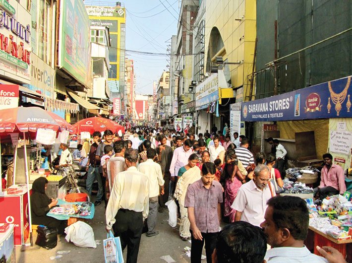
Chennai plans to expand its metropolitan area about seven times. Compacting development, ensuring sustainability and low-density sprawl are key concerns
Over the last decade, Chennai has been witnessing an unprecedented increase in urban population and a large expansion of industrial areas in its suburban regions. This expansion has largely been unorganised and haphazard. In order to regulate growth and make it uniform, the Tamil Nadu government has decided to increase Chennai’s metropolitan area seven times. As against the international norm of expanding cities vertically, ‘The Detroit of India’ is striving to grow horizontally.
Under the mega plan launched by housing and urban development minister Udumalai K Radhakrishnan, the area under the Chennai metropolitan development authority (CMDA) will increase from the existing 1,189 sq km to 8,878 sq km, covering Chennai, Kancheepuram and Tiruvallur districts, besides Arakkonam taluka of Vellore district.
Dharmendra Pratap Yadav, secretary of the state government’s housing and urban development department, says, “Yes, the expansion is coming late. Right from 1975, when the CMDA was formed, it has retained the same areas under its jurisdiction which were notified then. A lot of industrialisation has taken place over the past years. This has led to urban sprawl and ribbon developments.”
Talking about the institutional arrangement, Yadav says there were two options: one was to create a regional planning authority and allow the existing planning authorities to function within that new authority, while the regional planning authority would help them in preparing the master plan. The other option was to extend the area under the CMDA, which has the experience and the manpower to execute metropolitan kind of development, including the task to prepare a regional plan for the entire area.
So now, the CMDA will prepare a strategic regional plan and then a master plan to expand the area, define development boundaries, and fix land use accordingly.
Yadav explains that under the plan “we propose to reduce further concentration of people in Chennai to decongest it. We will be identifying development nodes or growth centres – places that are developing as new townships or expanding townships”. The idea is to concentrate on the development of these growth centres, which will include residential development, by providing facilities and properly planning them, so that urban sprawl is avoided. “By doing that, we can shift the population to identified potentially growing cities around. This will require focused infrastructural development, which will also reduce the cost of investment. In sprawl-based development, we have to linearly provide infrastructure in a concentrated place,” he says.
The objective of the plan is to have regulated growth and development along the transport corridors and also without disturbing the ecology of the area. “Aspects like formation of proper road linkage, adopting the walk-to-work model, change in land use and planning parameters such as floor space index, conservation of reserve forest and wetlands, and protecting agricultural land will be covered in the plan,” says a CMDA official.
Yadav says, “There is a lot of connectivity from the highway itself. Industrial areas like Oragadam, Sholinganallur, Kelambakkam, GST Road and Mahabalipuram towards the south are the main corridors. Similarly in the north, there is Kolkata Road. We will identify areas along these long corridors and focus on development in these areas.”
But urban planning experts say the plan is ambitious. They have concerns.
When the metropolitan region grows, the rules that apply to city development, that is, the development control regulations, will start applying in the newly added areas as well. In terms of the built form, the city will grow outward. The CMDA needs to ensure that the growth happens at a moderate rate, unlike the current situation where expansion is happening rapidly and in an unregulated way.
“The city limits are expanding,” says Chennai-based urban designer Vidhya Mohankumar. “More areas will come under the CMDA and the development regulations will change.”
The Directorate of Town and Country Planning (DTCP), under the state housing and urban development department, has jurisdiction over all of Tamil Nadu except areas under the CMDA. So, some areas which come under DTCP would now be under CMDA.
“My understanding of a regional plan is that it protects both the rural and the urban, and the characteristics of both. But in their version of the regional plan, it appears that they are going to just expand and make it a larger version of the city. This has kind of happened in Bengaluru. They expanded the limits horizontally and the city grew in all directions. The same thing is expected in Chennai. I don’t think there is a different approach to the way they are seeing a regional plan,” she says.
Horizontal vs vertical
Urban planning experts believe that the decision to expand Chennai horizontally rather than vertically is in the wrong direction.
Mohankumar says that somehow governments think that in Indian cities, in order to accommodate migratory population or a general increase in population, the only way forward is to spread horizontally. But historically, it has been seen that cities that spread horizontally have been unsuccessful.
What leads to horizontal expansion of urbanised areas?
Cities typically see cost of land increasing in central areas due to concentration of economic activity and more people seeking space for housing and businesses. The natural response is to increase the allowed density so that people can create more floor space. However, in Indian cities, the densities are capped well below what the market would support. As a result, people have to look outward to find space for development. This results in horizontal expansion of urban area.
What needs to be looked at?
- A regional plan that strengthens both urban and rural areas. The plan needs to also look at tier 2 and tier 3 cities and villages
- Cities need to look at vertical growth. It can be as simple as having five-storey buildings. They are a good scale as they ensure decent level of density and the resources and infrastructure such as drainage and floors can be upgraded to accommodate people
- Barcelona is a good example that followed vertical expansion. They have built few 20- or 30-storey buildings, but the uniform density of the city is maintained at four-storey or five-storey buildings. This can be a model for cites like Chennai
- Expansion and redevelopment should be area/locality specific
- Expansion should be carried out keeping the city’s heritage value intact
She explains that when the city expands 4,000-8,000 sq km, it becomes difficult to manage the area – in terms of control and sustainability.
There is a possibility that the area will be broken into municipalities and, each gets to decide its development control regulations – leading to decentralisation. But this is not going to be useful because, at the end of day, it is still one urban agglomeration and municipalities will continue to interact or rely on the core corporation area for basic services.
The other aspect is sustainability. Right now, there is no urban growth boundary and there is a need to compact the development. Growing horizontally is unsustainable because the consumption of land is very high. It involves swallowing agricultural lands and villages in the periphery. “In a regional framework for development, we look at strengthening towns and villages that may be a part of a larger urban agglomeration. That’s not the way they look at it. They look at horizontally sweeping across, covering all the towns and bringing everything into the fold of the city. And this is what is unsustainable as we are killing those towns and villages and their characteristics,” she says.
“There is no concept of compacting the development, as in, consolidating the existing area and looking at alternative ways of infill development [the use of land within a built-up area for further construction] like integrating the land use and the transportation network in a way that it allows you to compact the city and grow vertically,” she adds.
According to her, we are creating a problem for ourselves in terms of managing infrastructure and outlay. The cost of developing horizontally, in laying infrastructure, is high, time consuming and energy resource consuming.
Achieving transit-oriented development in Chennai
Excerpts from the feedback given by the Institute for Transportation and Development Policy to the CMDA on the Chennai metro rail densification study
Chennai city has relatively high population density compared to many cities in the world. However, such high population density isn’t matched by adequate built space, open green space, and support infrastructure, resulting in poor quality of life for the vast majority of the population. Under the present regulatory regime (and market response to the regulations) formal home ownership is not possible for a significant portion of the population. For others, it is possible only in far flung areas, resulting in urban sprawl. It is estimated that Chennai city’s population will grow by nearly 20 percent in the next 15 years [from 4.95 million (2011) to 5.86 million (2026)]. If this population is not accommodated close to rapid transit corridors, it will lead to greater dependence on private motor vehicles. Further, increasing income levels lead to higher per capita consumption of floor space. Thus, there is an inherent need for greater amount of built space with easy access to rapid transit corridors.
While the densification study acknowledges the need to accommodate this increased population close to rapid transit, and concludes that built space densification is desirable based on international experience, it also identifies critical obstacles. These barriers include inadequate provision of infrastructure facilities within the city and the difficulties in augmenting existing services. The presence of small plots and under-utilised land is also highlighted as a deterrent to redevelopment.
On the other hand, findings from the study suggest that buildings on smaller plots on narrow streets have, in practice, consumed higher FSI than multistory buildings on large plots. Under the prevailing socio-economic and political environment, such pockets of already congested development are likely to become even more dense, but in an unplanned manner – with no open spaces and no support infrastructure. Yet, with proper planning, better infrastructure and the right incentives, much higher densities of built space as well as population can be accommodated, better infrastructure and much higher quality of life. The station areas will certainly redevelop and densify. The choice is whether to plan for and guide that process and use it as an opportunity to transform these areas, or just sit back and let chaos reign.
Giving the example of the national capital region (NCR), she says that Noida, Gurgaon and Faridabad are still outside Delhi and the infrastructural development in these areas is not highly talked about. Also, building the character of these towns has yet not been taken care of. The reason for this is that we look at development in a tangible manner. Intangibles like culture, environment and ecology are lost in the process.
Christopher Kost, the Africa programme director at the Institute for Transportation and Development Policy (ITDP), has worked in Chennai and is familiar with the city’s planning issues. He says that the expansion of the development authority area isn’t an issue per se, provided that the authority’s policies are focused on containing growth around public transport corridors within the existing urbanised area. However, current building control and zoning policies in Chennai encourage a low-density sprawl that is resulting in rapid horizontal expansion of the city. Residents face longer commutes and it’s expensive to provide utilities and transport services to these far-flung areas. “It would be much more environmentally sustainable and cost-effective to encourage vertical growth,” he says.
But, “expanding the extent of the authority’s jurisdiction could actually be a good thing – if the agency were using that influence to prevent sprawl within this area. With the present policies, the expanded area might create an incentive to encourage more sprawl,” he adds.
In Chennai, provisions of infrastructure follow urban expansion. People build houses, and then the relevant agencies struggle to catch up with water supply lines, sewage, roads, etc. In the meantime, people make do with boreholes, septic tanks and the like. “This situation should be turned around such that agencies can plan proactively for urban expansion, creating street networks and laying down basic utilities in order to guide urban expansion,” suggests Kost. If these facilities are provided beforehand, the resulting development can be much denser. For instance, he says, in Gujarat, there is a well-established town planning scheme whereby the government re-adjusts plots and provides basic infrastructure before converting the land to urban zoning.
Furthermore, the expansion of the CMDA could affect rural areas, especially in its road projects. “They [roads] can improve access but they are often designed without any provision for pedestrians, cyclists or public transport,” he adds.
Retaining identity
Heritage enthusiasts are concerned that the identity of the older parts of the city should be retained in the exercise of expansion and redevelopment.
S Suresh, archaeologist and Tamil Nadu state convener of the Indian National Trust for Art and Cultural Heritage (INTACH), says that the city needs laws to regulate development in the older areas. The authorities must realise that the older areas cannot be developed in the same way as the newer ones.
Highlights of the city expansion
- The CMDA’s second master plan, released in 2008, estimates that the population of Chennai metropolitan area will touch 12.5 million by 2026
- The ITDP estimates that Chennai city’s population will grow by nearly 20 percent in the next 15 years – from 4.95 million (2011) to 5.86 million (2026)
- From its existing 1,189 sq km the Chennai metropolitan area will be expanded to cover 8,878 sq km
- The Chennai mega region will cover Chennai, Kancheepuram and Tiruvallur districts, and Arakkonam taluka of Vellore district
- The plan will include formation of urban centres and potential growth centres, proper road linkage. It will encourage the walk-to-work model or living next to the workplace, changes in land use, changes in FSI and the like, conservation of reserve forest and wetlands, and protection of agricultural land
The CMDA is listing heritage buildings in the city as well as in the outer areas which will now come under its jurisdiction. Suresh feels that the expansion should be done in a heritage-sensitive way. There have been master plans for Chennai earlier also. “A master plan is welcome but any plan cannot be uniform for the whole city. Even if we take a small area in the city, like from George Town to Thiruvanmiyur, in between, there are so many localities of different types. Hence, we need different types of development regulations for them, so that their identities are not tampered with,” he says. Any plan, whether it is urban planning or development planning, has to take local conditions, requirements and aspirations of each area into consideration. “Some of the small areas may be totally undocumented. The agencies have to do a careful study as some small areas may be well developed and may qualify as urban satellite centres and others may be more rural and may need a different type of approach for development,” he says, adding that the challenges ahead are many for the authorities and “since their responsibility and work load will increase, we hope they rise to the occasion.”
Yadav admits that there are challenges. “The biggest task is to prepare the strategic regional plan and then keeping that in view work on the master plan for the entire area.” The regional plan will broadly classify the areas that will be urbanised, those that will remain agricultural lands and those that will remain as forest lands. “Based on resource mapping we can see where industries will come, how walk-to-work concept will be promoted, what will be the water requirement for the entire region and how it can be planned,” he says.
Asked about the impact on the rural areas, Yadav says that those won’t get affected. “Through this initiative we want to preserve agricultural lands by disallowing sprawl or ribbon development and focus on existing growth centres and planning all development within and around these alone, rather than unregulated growth and habitations here. This will check unrestricted conversion of agriculture lands in the absence of proper planning,” he says.
“We need a lot of trained manpower and town planners. We will be increasing the strength of planners at the CMDA. Many stakeholders are involved including traffic, transportation, water and sewage, forest and agriculture, and they will work in the framework of the master and the regional plan.”
[email protected]
(The article appears in the September 30, 2017 issue)